
Mavrovo National Park – between the shade of the forest and Bistra’s open mountains
Mavrovo village, accommodation and ski slopes lie by Lake Mavrovo. Above them, Bistra’s forests and open heights begin. In Mavrovo National Park, village life and mountain hiking can be part of the same trip – but a short outing and a demanding day in the mountains need to be planned in very different ways.
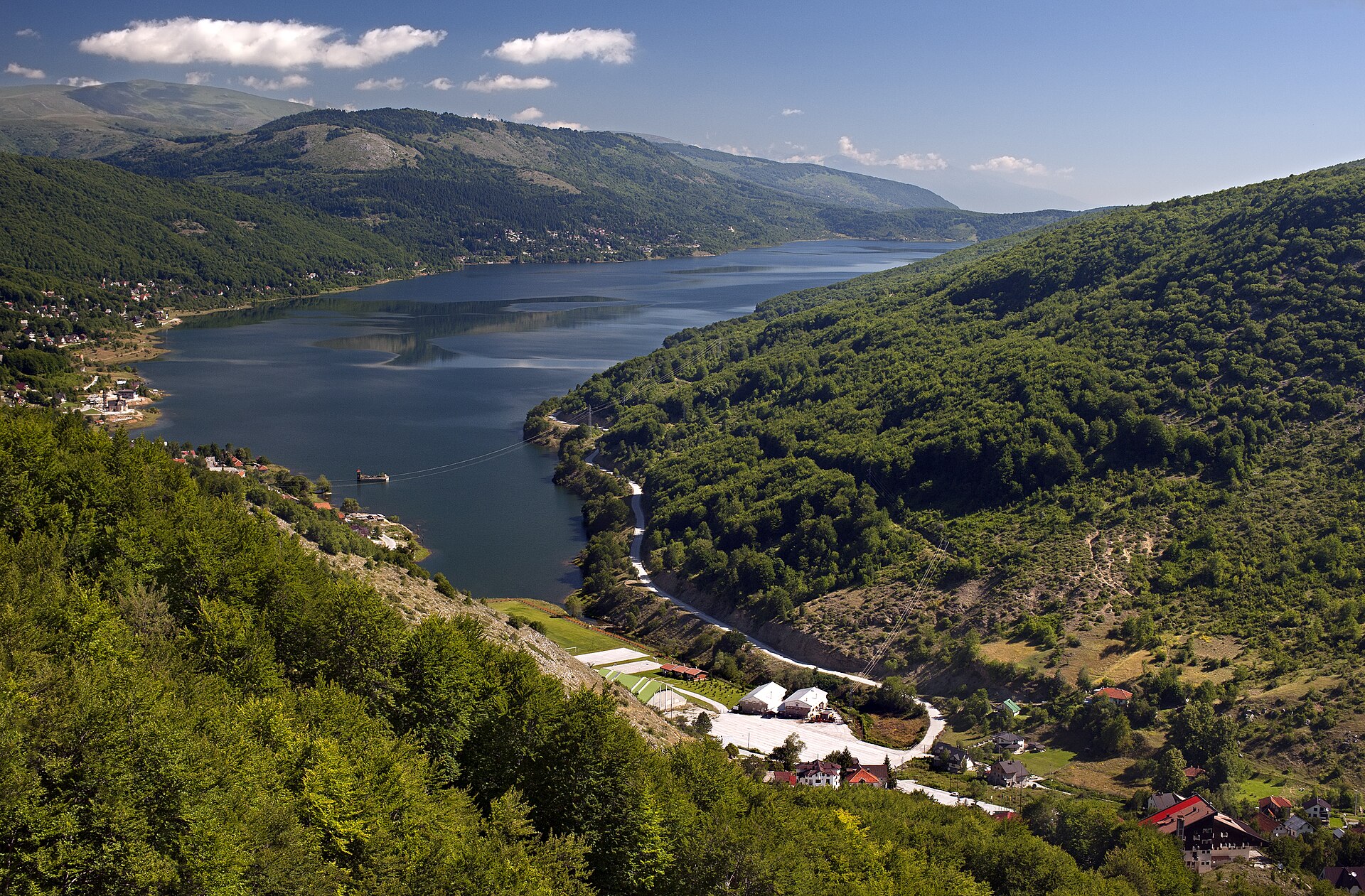
The ski slopes above Mavrovo village give you a first sense of the terrain. Here, the mountain rises straight behind the buildings; the lake is a landmark down in the valley, not a promise of easy, level walking. As you climb, the village gives way to forest and eventually to more open country, where the weather has more say.
That transition is what makes Mavrovo National Park in western North Macedonia so interesting. A trip here does not have to revolve around a summit. It can just as easily be about following the landscape through its different levels: the lake and villages, the forested slopes, Bistra’s grasslands. But the distances between experiences are measured in more than what the map shows. Elevation gain, terrain and exposure determine how demanding the day will be.
Those familiar with Nordic mountains will recognise the treeless heights. At the same time, this is a different mountain landscape, where villages, pastures and ski resorts are part of the same geography as the hiking routes.
From beech forest to open heights
Mavrovo is not a single mountain or one continuous area of treeless mountain terrain. Bistra defines the area above Mavrovo village and Galičnik, while Korab belongs to the park’s western mountain region. The Radika valley cuts through the landscape, offering different perspectives from the heights around the lake. Choosing a base therefore also means choosing which part of the park the trip will revolve around.
Around Bistra, forest meets open pastureland. The canopy of the beech forests creates a different setting from mountain birch forest: more enclosed spaces, shade and limited views. This is a landscape where the path through the forest can be the experience in itself, not just a way to reach a viewpoint.
Above the forest, conditions change. You can see further, but there is less shelter from the sun and wind. Nor does a seemingly gentle, grassy slope tell you for certain how easy the route will be. What looks continuous from a distance may be broken up by hollows, steeper sections and junctions.
So let the transition between forest and open mountain country inform your route choice. A walk that stays in sheltered terrain is different from a day that continues over exposed heights, even if both start from the same village.
Start near Mavrovo village
Mavrovo village is a natural starting point for getting to know the southern part of the lake and the slopes around the ski area. Hotel Bistra is among the accommodation here, and the combination of buildings, lake and mountains makes the place appealing even without a long hike every day.
A first outing can be modest in ambition: get to know the village, seek out views across the water and get your bearings in relation to the mountains. It is important, though, to distinguish this kind of walk from a recommended hiking trail. The lake being close does not mean there is an unbroken, easy path along the shore. Nor is a ski slope automatically a suitable summer route.
For a short forest walk, ask the park administration for a current suggestion for a marked trail. Explain what you mean by short and easy: the amount of climbing you want, the type of terrain you can manage and whether you need to be able to turn back early. Also ask for a clear starting point. A place name is not enough to guide you to a trail.
An out-and-back walk along the same confirmed stretch can be a good way to keep the day manageable. That way, you do not have to complete a loop to get back. The aim of the first day is not to reach a high point, but to get a feel for the terrain before taking a longer walk.
Mavrovo–Smrdlivi Virovi needs its own plan
The Mavrovo–Smrdlivi Virovi route belongs in a different planning conversation from a walk through the village. Do not choose it just because the starting point is familiar or because pictures of open meadows make it look easy to walk.
You need an up-to-date route description before you can assess the walk: the exact start and finish, distance, total elevation gain, estimated time and how the route is marked. The information available is not enough to provide verified figures for these details. The route is therefore not presented here as a ready-made recommendation.
That distinction matters. The name of a hike can remain in use long after a description has been published, while access conditions and trail markings change. Also check whether a stated distance is one way or for the whole route. Otherwise, you cannot judge whether the day is within your experience and stamina.
Ask the park administration or a local hiking guide to go through the route with you. If the route choices remain unclear, a guided walk or another confirmed trail is a better choice than improvising. A demanding day in the mountains begins with knowing what to expect, not hoping the terrain will work itself out along the way.
Two villages, different trips
Mavrovo and Galičnik give a trip different focal points. In Mavrovo, the lake and ski area are close to the village. It suits a stay where hiking can be mixed with shorter outings and time by the water.
Galičnik lies in Bistra’s mountain landscape and has a different character, with stone houses on the slopes and strong ties to the area’s pastoral culture. Here, the village itself becomes part of the mountain experience. The incline of the streets, the position of the houses and the open land around them tell the story of how people have lived and worked in this terrain.
Food adds another layer of context. Ask for kačkavalj from Galičnik, an aged yellow cheese connected to the area’s cheesemaking tradition. It is a tangible way to connect a meal with the landscape, without turning the whole visit into a history tour.
But an appealing village is not automatically a practical base for every hike. Check that your intended accommodation and somewhere to eat are actually available on your travel dates. Find out where the trail starts and how to get there. Staying in Galičnik is not the same as staying by Lake Mavrovo, and accommodation listed as being in Mavrovo may be in another part of the lake area, such as Mavrovi Anovi.
Don’t plan around Nordic habits
Experience in the Nordic countries is useful when assessing the weather, what to pack and your own stamina. But it should not lead you to make assumptions about local conditions. Do not assume that trail markings, water points, transport or camping opportunities work as they do at home.
Choose marked trails and ask the park administration about current trail conditions, any restrictions and snow along your planned route. Greenery down by the lake tells you nothing about conditions higher up. Also make sure you know how you will get water; a stream on a map is not a confirmed drinking-water point.
Arrange transport to the starting point and back before setting off. If you plan to stay outdoors overnight, check the park’s current rules and permitted locations. Nordic right-to-roam access does not apply here.
Mavrovo’s strength is that hiking can take many forms. A day close to the village does not have to be a spare day, and a meal in Galičnik does not have to be just something to fill the time between hikes. The forest, pastures and settlements belong together. Choose a mountain day that is properly planned, and let the rest of the trip make room for the landscape you came to discover.
Facts
- Country/region: western North Macedonia
- National park since: 1949, the country’s largest
- Highest peak: Korab, 2,764 m (on the border with Albania)
- Lake Mavrovo: an artificial lake, created in the mid-20th century
- Nearest airport: Skopje
Sources & further reading
- pathismygoal.comHiking in Mavrovo national park through beautiful meadows - Path is my goal
- macedonia-car-rental.comMavrovo National Park: Complete Visitor Guide 2026
- slowroads.euMavrovo National Park Highlands | Scenic route North Macedonia
Share the article
Translated from Swedish with AI assistance. Read the original.


